


このアプリのYoutube動画がある場合はURLを送信してください。詳細 »
APPLICATION INFO - iPhoneアプリの詳細情報
Complete reference for symbols, abbreviations and terms used in marine charts. Useful as an aid for teaching and learning, or as reminder for experienced sailors and sea cartography users.
INCLUDES
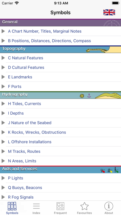
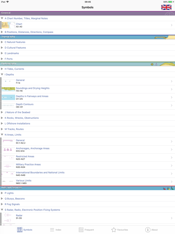
- Comprehensive coverage: more than 800 symbols and abbreviations.
- Full content tree, organised for ease of use.
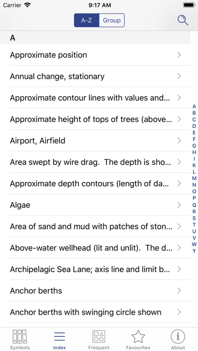
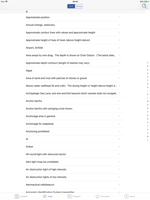
- Index and grouped index for all entries.
- Search facility.
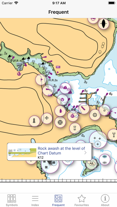
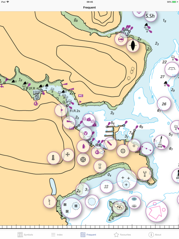
- Sample chart with visual popups for commonly used symbols.
- Favourites: archive your best symbols.
- Multi-language within the app (English/French).
Full international standard from the IHO.All topics from the IHO, UKHO, SHOM, NOAA, CHS and other hydrographic offices:
position, distance, direction, compass, features, landmarks, ports, tides, currents, seabed, rocks, wrecks, obstructions, offshore, tracks, routes, areas, limits, lights, buoys, beacons, fog, radar, radio, services, small craft.
LANGUAGES
English, French, German, Italian, Spanish
ABOUT US
Imray are a leading chart and marine book publishers, based in England and with a catalogue of charts for Europe, the Mediterranean and the Caribbean. Imray's pilot books cover the whole world in extensive detail.
In partnership with Imray, software developers and sailors.
Follow us on Twitter - http://twitter.com/imray_charts
Facebook - imraynautical
Look out for other applications in the Marine Navigation Series from Imray:
TIDES PLANNER - tide predictions any date
RULES & SIGNALS- Rule of the Road, signals at sea.
RACING RULES - RYA Handy Guide to rules for sailing races
INCLUDES
- Comprehensive coverage: more than 800 symbols and abbreviations.
- Full content tree, organised for ease of use.
- Index and grouped index for all entries.
- Search facility.
- Sample chart with visual popups for commonly used symbols.
- Favourites: archive your best symbols.
- Multi-language within the app (English/French).
Full international standard from the IHO.All topics from the IHO, UKHO, SHOM, NOAA, CHS and other hydrographic offices:
position, distance, direction, compass, features, landmarks, ports, tides, currents, seabed, rocks, wrecks, obstructions, offshore, tracks, routes, areas, limits, lights, buoys, beacons, fog, radar, radio, services, small craft.
LANGUAGES
English, French, German, Italian, Spanish
ABOUT US
Imray are a leading chart and marine book publishers, based in England and with a catalogue of charts for Europe, the Mediterranean and the Caribbean. Imray's pilot books cover the whole world in extensive detail.
In partnership with Imray, software developers and sailors.
Follow us on Twitter - http://twitter.com/imray_charts
Facebook - imraynautical
Look out for other applications in the Marine Navigation Series from Imray:
TIDES PLANNER - tide predictions any date
RULES & SIGNALS- Rule of the Road, signals at sea.
RACING RULES - RYA Handy Guide to rules for sailing races
 このアプリはiPhone、iPadの両方に対応しています。
カテゴリー
ナビゲーション
ナビゲーション
リリース
2010/2/19
2010/2/19
更新
2019/10/7
2019/10/7
バージョン
2.1.0
2.1.0
言語
日本語, 英語, フランス語, ドイツ語, イタリア語, スペイン語
日本語, 英語, フランス語, ドイツ語, イタリア語, スペイン語
サイズ
36 MB
36 MB
条件
iPhone、iPod touch および iPad 互換 iOS 3.0 以降が必要
iPhone、iPod touch および iPad 互換 iOS 3.0 以降が必要
このバージョンの新機能
• iOS13 compatibility including dark mode.
• iOS13 compatibility including dark mode.
スクリーンショット - iPhone | iPad
スクリーンショット - iPhone | iPad
» 目的別iPhoneアプリ検索
- 辞書 » 日本語対応の辞書 » 英和辞典
- 学習 » 英単語 » 英会話 » クイズで楽しく
- スケジュール » 管理 » Googleカレンダー


CatchApp新着アプリレビュー
 日本縦断てつどうの旅」")
様々な楽しみ方で運転士として成長していく鉄道運転士育成RPG「プラチナ・トレイン(プラトレ) 日本縦断てつどうの旅」
2016-05-17 00:00

日本語にはない英語発音のリスニングを楽しく学べる「発音どっち?英語リスニング 」
2014-12-20 12:00

指先の瞬発力が試されるカジュアルゲーム「早撃ちパニック」をリリース!
2014-12-08 15:21
新着アプリ動画
-
 ¥1500
¥1500

-
 ¥600
¥600
-
 ¥3000
¥3000